Showing posts with label Supai. Show all posts

Thursday, February 11, 2021

Why ‘Point Sublime’ all but disappeared at the Grand Canyon, North Rim; Plus, Yellowstone’s old Point Sublime trail to the river


                                    The sign to the North Rim of the Grand Canyon.


WHY
 is the lodge and centerpiece of the North Rim of the Grand Canyon located where it is and what happened to Point Sublime, early ballyhooed viewpoint?

(OK, the world-renowned Grand Canyon, North Rim, isn’t in Utah, but its beginnings and history relied heavily on Kanab and Cedar City.)

The first decades of trips to the North Rim always focused on Point Sublime, located about 17 miles west of today’s lodge at the North Rim. This point was so named because the earliest of visitors to the Grand Canyon all seemed to agree this was the most stupendous view of all to be found – on either rim.


The Salt Lake Herald of December 7, 1892 reported on a large group of men visiting the North Rim on primarily a wild game trip with “Buffalo Bill.” The group visited Point Sublime and even Bright Angel Point (location of today’s North Rim lodge). Brigham Young, grandson of Brigham Young was the primary guide in the Grand Canyon area, though his horse fell and rolled down a mountain, badly injuring Young.

A February 26, 1905 story in the Salt Lake Herald said that Point Sublime is “where all descriptions fail” and that place offers a view of six amphitheaters so vast the Yosemite Valley and all of its wonders could be hidden away in a corner there.

According to the Los Angeles Times of September 7, 1905, it was Col. William F. Cody in a group that included John W. Young (a son of Brigham Young) who first proposed the idea of making a national park from the Kaibab Plateau of the Grand Canyon.

The same group also proposed an aerial tramway for the Grand Canyon, to provide inner canyon access for everyone.

                                      Today's North Rim Lodge, as seen from the southeast.

The Deseret Evening News of March 24, 1906 stated another reason for the early popularity of Point Sublime – there was a copper mine there, frequented by Utah miners. One such group of miners that winter had underestimated the severity of snowfall on the Kaibab Plateau and with a lack of provisions, had to survive on just meat for 12 days before they got back to Kabab. The group also thought it depressing that they could see the railroad running on the South Rim of the Grand Canyon, just 12 or so miles distant, but could not profit from that.

                                A 1933 map of the North Rim, from the Piute County News.

“Million dollar hotel for Point Sublime” was a June 15, 1916 headline in the Washington  County News of St. George. That dream has never realized.

The Deseret News of August 16, 1917 reported that “Point Sublime reached now by automobile.”

Dr. George Worthen James, author, speaking to the Salt Lake Rotary Club declared, “that the best point from which to view the Grand Canyon of the Colorado can be reached through Utah and northern Arizona, this being Point Sublime on the north rim.”

That was stated in the Salt Lake Herald-Republican newspaper of June 16, 1920. Dr. James said probably only 10 men in the room realized that now. (He also inaccurately predicted that one day 5 people will view the Grand Canyon from the North Rim for every 1 at the South Rim, when the reverse actually happened at an even higher rate.)

However, the July 25, 1920 Salt Lake Telegram stated that there was much bitterness over the fact that the Department of Parks had denied automobile access to the North Rim’s “two big view points” -- Point Sublime and “Skidoo Point” (today’s Point Imperial), in favor of only allowing road travel to Bright Angel Point.


                                                 The North Rim at Bright Angel.

The Salt Lake Tribune of June 22, 1923 stated, “The automobile road of today brings one only to Bright Angel Point. In the days of wagons, people journeyed westerly to Powell’s Plateau and to Point Sublime, a stupendous, soul-stirring viewpoint …”

Thus, it was when the Grand Canyon became a national park in 1920 that Point Sublime and the viewpoints east of Bright Angel were not open to autos. (Though in the later decades, good roads were made eastward to Point Imperial and Cape Royal, but western views from Bright Angel were still denied.)

Today, Point Sublime is only accessible by a very rugged 17-mile, one-way, four-wheel drive path. Or, there’s the five-mile-long Widforss Trail for hikers, that travels almost a third of the way west, toward Point Sublime, but ends at Widforss Point (named for artist Gunnar Widforss, who painted the Grand Canyon in the 1920s-1930s).


    There's still a great view of the Grand Canyon from where the North Rim Lodge is today.

The National Parks Service designated Union Pacific Railroad to initially develop the North Rim. Although it never made a rail line there, it chose Bright Angel Point as centerpiece for the North Rim primarily because Roaring Springs below offered reliable water, a scarcity in the area. (In fact, even today Roaring Springs water is piped to the South Rim as their main source of H2O, though studies are now underway to seek a closer underground water source around Phantom Ranch at the bottom of the canyon).


                                     Today's North Rim Lodge blends into the native rock.

The North Rim Lodge opened in 1928 after construction continued during an entire snowy winter to do so. The lodge eventually featured 140 nearby cabins.

However, a fire completely destroyed the four-year-old lodge on September 1, 1932. Despite the Great Depression, the Utah Parks Company

(designated concessions company) rebuilt a smaller, but sturdier lodge by 1937, using original materials leftover from the fire.

The lodge did close during most of World War II, but has been open ever since.


                      The start of the trail to Supai today from Hilltop.           Photo by Ravell Call.

-Here’s yet another intriguing Grand Canyon historical tidbit: According to the Arizona Republican newspaper of Phoenix from April 27, 1925, plans were being made to build an automobile road to Supai, at the bottom of Havasu Canyon. This was to allow visitors to “see one of the most interesting of Indian tribes in their canyon retreat” and enjoy “its beautiful waterfalls.” The road never happened and nothing but a foot/horse trail (or helicopter travel) can access Supai today.


              The trail to Supai after the first switchbacks.  Photo by Ravell Call.


-BACK TO THE REGULAR GRAND CANYON -The North Kaibab trail in the Grand Canyon from the North Rim to Phantom Ranch is one of the longest canyon trails, at 14 miles.

(Compare that to the South Rim’s Bright Angel Trail, 9.9 miles, or the South Kaibab at 7.4 miles. Descent or climb wise, the North Kaibab is 5,850 feet in elevation change vs. 4,860 feet for the South Kaibab, or 4,460 for the Bright Angel.)

The North Kaibab lacks the spectacular Grand Canyon views that the South Kaibab has, because it is located in a deep side canyon, where Bright Angel Creek flows down.

According to the Arizona Republican newspaper of Phoenix on August 16, 1921, the North Kaibab trail was a nightmare for hikers in its early years.

“The almost ice-cold creek had to be crossed 117 times between the Colorado River and the North Rim; and this in itself is no picnic,” the story stated.

It also advised that only “a seasoned athlete who has no objection to strenuously roughing it” could handle the rugged path up or down.

Only five hunting parties had went up or down the North Rim that season, because of the rough trail involved.

-However, some 11 years earlier, Emory C. Kolb, youngest of the Kolb photographers on the South Rim, did make a daring solo jaunt across the Grand Canyon sometime in the early summer of 1910.

According to the Arizona Daily Star of Tucson on June 28, 1910, Kolb volunteered to deliver a message to a tourist on the North Rim and he did it in one day.

When he got down to the Colorado River, there was no one to help pull the cable across the water, so Kolb had to overhand the 450-foot-long cable – and his thermometer measured 100 degrees that day. Then, he proceeded up the wild North Kaibab trail and did find the woman to deliver the letter to on top.

                                                     The Grand Canyon of the Yellowstone


-The North Kaibab trail has also had a number of washouts over the decades. For example, in August of 1936, a cloudburst not only wiped out most of the trail coming down from the North Rim, but it also destroyed 3,000 feet of the pipeline from Roaring Springs, that supplies the North Rim.
Two hikers were on the North Kaibab trail at the time of the cloudburst and narrowly escaped with their lives. They had to cling to a two-foot-wide ledge to barely be above the waterline. (-From the Williams News, Aug. 28, 1936.)
-Another heavy rainstorm in August of 1948 also severely damaged the North Kaibab trail and mule trips down could not be resumed that summer. (-From the Arizona Daily Sun on Aug. 11, 1948.)

-YELLOWSTONE NATIONAL PARK also boasts its own Point Sublime. Named in the early years of that National Park, it is located just north of Artist’s Point on the Grand Canyon of the Yellowstone River.

However, today there’s just a three-mile roundtrip trail to Point Sublime and back and most visitors call it a “disappointment,” according to on-line reviews by hikers.

Why is it a disappointment?

Simply because it isn’t what it used to be.


“New attraction offered at Park.

The story explained that since the close of the 1920 season, work on cutting a trail to the BOTTOM of the Grand Canyon of the Yellowstone was done. The result is a horse that actually leads to the river level, not just the rim.

The story states that this is the second trail that leads to the bottom of the Grand Canyon of the Yellowstone. The other is the Uncle Tom’s footrail that is located southwest of Artist’s Point.

Today, Uncle Tom’s Trail is the ONLY trail that goes to the bottom of Yellowstone’s Grand Canyon. How long the Sublime under the rim trail was open is unknown.

Danger likely closed the Sublime descending trail and erosion may have obliterated all traces of it under the rim trail.


Friday, September 27, 2013

Supai: The Grand Canyon Village Without Automobiles

            Supai area boasts a John Wayne kind of Wild West Landscape.

                                                     All photographs by Ravell Call.

                             Few parts of Supai are paved.


                                       Mooney Falls


Envision a world without automobiles ...
Imagine a tucked-away red-rock pocket without paved roads (let alone automobiles), where the hustle and bustle of modern life is almost nonexistent.
Add a remarkable, year-round, spring-fed stream of blue-green water that plunges off spectacular waterfalls, complete with picturesque, travertine-sculpted pools.

Mix in trees and plants not always found in such a desert locale, and include American Indians who have called this once-hidden chasm home for centuries.
There. You now have a barely adequate description of northern Arizona's beautiful Havasu Canyon and the village of Supai — likely the most remote town in the lower 48 states.
It is, as National Geographic once phrased it, the "Shangri-La of the Grand Canyon," of which Havasu is a tributary cleft.


"Even today many visitors to the Southwest learn with surprise of this community of Native Americans living within the Grand Canyon," Stephen Hirst wrote in an enlightening book about the tiny tribe, today about 500 people occupying an equal number of acres. "The people call themselves havsuw 'baaja — the Blue Creek people — and so number themselves among the few Native Americans who the Europeans call by anything close to their own name for themselves." They are the Havasupai — the final syllable meaning "people."
Of course, there is a catch to this scenic paradise. There are only three ways into the area:
By hiking.
By horseback.
By helicopter.


Also, while most visit here because of the spectacular 

waterfalls, found a mile or so below the village, many find 

that the most intriguing thing here are the Native Americans 

who live here as they have for centuries.


---------------------------------------------

--Note that this paradise is not without its dangers, though. 

A  flood on August 16, 2008 closed the area to tourism for 

some  weeks. Trails were heavily damaged and some 

waterfalls were even reshaped.

Periodic floods are a part of the landscape here. There was 

another flash flood in July of 2012 and another back in 

2001.

-------------------------------------------
'Best swimming hole'
                                                 Havasu Falls.

Supai itself is, as the raven flies, about 35 miles southwest of the South Rim's Grand Canyon Village. But getting there is really a bit of a challenge, as our group of nine — ages 8 to 58 — found on a spring trek there back in April of 2004.
For instance, after getting to Hualapai Hilltop — road's end, which is itself 60 miles from old Route 66 — the hike to Supai is an eight-mile trek down a cliff and through a sand- and gravel-bottomed wash. Then it's another two or so miles, one way, to the waterfalls — Navajo, Havasu and Mooney — just below the village on Havasu Creek.
Plus, to be one of the 25,000 outlanders who visit each year, you have to have an advance reservation to visit what Life Magazine once called "the best swimming hole in the nation."
                                          Supai Motel

According to Billy Jack, with Havasupai Tourist Enterprises in Supai, Havasu's campgrounds and small lodge are at their busiest from late March through June and are usually booked solid. July and August are not only the hottest months, when daytime highs can reach 115 degrees, but also the monsoon rainy season, which can create flash-flood hazards in the narrow canyons. Those two months have 50 percent vacancy rates. Then from October until early spring the area is seldom visited. Snow occasionally falls in winter, but it always melts off quickly.
Most of the camping area in the canyon is situated right along Havasu Creek between Havasu Falls and Mooney Falls, a pleasant locale that can handle 200 backpackers a day.
The basic but quite comfortable lodge in Supai has 24 rooms that can accommodate up to four people each. (There are, however, no TVs or phones.)
                                          Supai Restaurant


                                       Inside the restaurant.

A store, restaurant, post office and emergency medical clinic are also available in Supai's center.
Indeed, tourism is the village's main industry. Villagers receive no government stipends and pay income taxes, like all Americans do, Billy Jack says.
The biggest problem the tribe encounters, he says, is people who try to make a day hike out of this experience. They usually get into trouble, trying to do 20 miles in a day.
"We don't recommend 'day hikes,' " he said. Night hiking is 

also not advised for those unfamiliar with the area.
A rewarding trek
Our two-day trek — in the end we wish it had been three — began on a brisk April morning that included a 20-mile drive through dense fog across the neighboring Hualapai Reservation to the Hualapai Hilltop trailhead, essentially a cliff-hanging parking lot at 5,199 feet above sea level.

We started moderately early, about 8:30 a.m., after a 65-mile drive from our lodgings of the previous night, and we were glad we did. The descent was steady and the temperatures mild.
The first mile-plus turned out to be steep, following a series of switchbacks and quickly dropping a thousand feet.
The views were marvelous. The canyons quickly plunge below the rim, gray-white stone at times ribbed in shades of salmon and iron red like a fantastic marble cake. Chasms and escarpments fade to the south, west and especially to the north and toward the Grand Canyon itself in scope and panorama that movie director John Ford would have appreciated.
And the morning odors proved both bracing and familiar — those who've hiked other Grand Canyon trails used by horses and mules will know what we're talking about.
Indeed, pre-automotive age horsepower is key to life in Havasu Canyon. We encountered our first riderless and package-free mules — properly giving them the right of way — near the bottom of the cliff; they seemed to know where they were going (up) but proceeded in a slow-and-go sort of fashion. On the way back to Supai they will carry passengers, food, sundry goods and, yes, the U.S. mail.
After the steep descent bottoms out, the hike is along a mostly dry streambed for the final six or seven miles to the Indian village.
In the confined canyon, rock walls stretch heavenward. The sheer cliffs and tight corridors are reminiscent of Zion Canyon's narrows in places (without the Virgin River's stream), as well as many other side canyons of the Grand Canyon.
Then the trail intersects Havasu Canyon and its life-giving blue-green creek. The water's remarkable color is a result of a high mineral content and suspended carbonates — key elements, as travertine, that coalesce and coat the creek's path, and so visible at the creek's famous falls.


Flora Gregg Iliff, a teacher who traveled into Havasu over a century ago, wrote about her reactions to the sudden oasis of Havasu Creek in her only book, "People of the Blue Water."
"To eyes that had grown weary of gazing at stone, the lush verdure of Havasu Canyon, overshadowed by tall cottonwoods and old willows, seemed straight out of some fantasy. There was greenness and life and growth, and I could hear the purling of restless water."
Today Supai, about 2,000 feet below the trailhead, seems on first glimpse very like a small Western town from perhaps the 19th century.

Horses, mules and a few cattle feed, stand and loll in barren corrals lined by the valley's stolid trees.
The roads and paths are hard-packed dirt, muddy in spring from recent rains.
Most residents (except for some of the children) pay little 

notice to the incoming tourists. Their free-roaming dogs, 

however, are friendly and outgoing; they also seem to know 

the "town square," flanked by a small restaurant and the post 

office/general store, is a pretty good place to be.
Picture perfect
Supai sits in a wide section of Havasu Canyon, guarded by twin sandstone towers known as the Wigleeva rocks. Should these pinnacles topple, it is said, the Havasupai believe they will cease to exist. Small houses and fields fill the little valley, which is crisscrossed by narrow roads and small canals.

The principal path angles through the village, past a small Christian church and along Havasu Creek — headed down-canyon to the campground and waterfalls.
The first major cascades we noticed are part of Navajo Falls, surrounded by vegetation and named for a Havasupai chief.
Soon, a left turn (downward) at the "Havasu Campgrounds" sign, signals that the canyon's most famous cascades are nearby, just beyond a sylvan stretch of camping spots. (Be sure to take that turn! We took a little side trip to nowhere along some cliffs.)
A half-mile later, or about two miles from the village, and there we were: Havasu Falls, once known as Bridal Veil.
The setting seems like nothing less that exactly what a desert-oasis waterfall should look like.

Twin streams plunge 115 feet off a craggy travertine cliff into a perfect pool 25 feet deep. Smaller pools, sculpted by curving travertine dams formed by the calcite-laden water itself, added to the idyllic scene.
The creek issues from a large spring that drains much of the upper plateau, including the San Francisco Mountains area around Flagstaff. The water's temperature is about 70 degrees year-round.
Visitors tiptoe across the dams like gymnasts on beams. Others bask on the beaches. A few indulge in a swim or clamber onto a boulder beside the waterfall before leaping with a yelp into the translucent waters.
By this point the afternoon light was waning — and we had yet another spectacular waterfall to see.
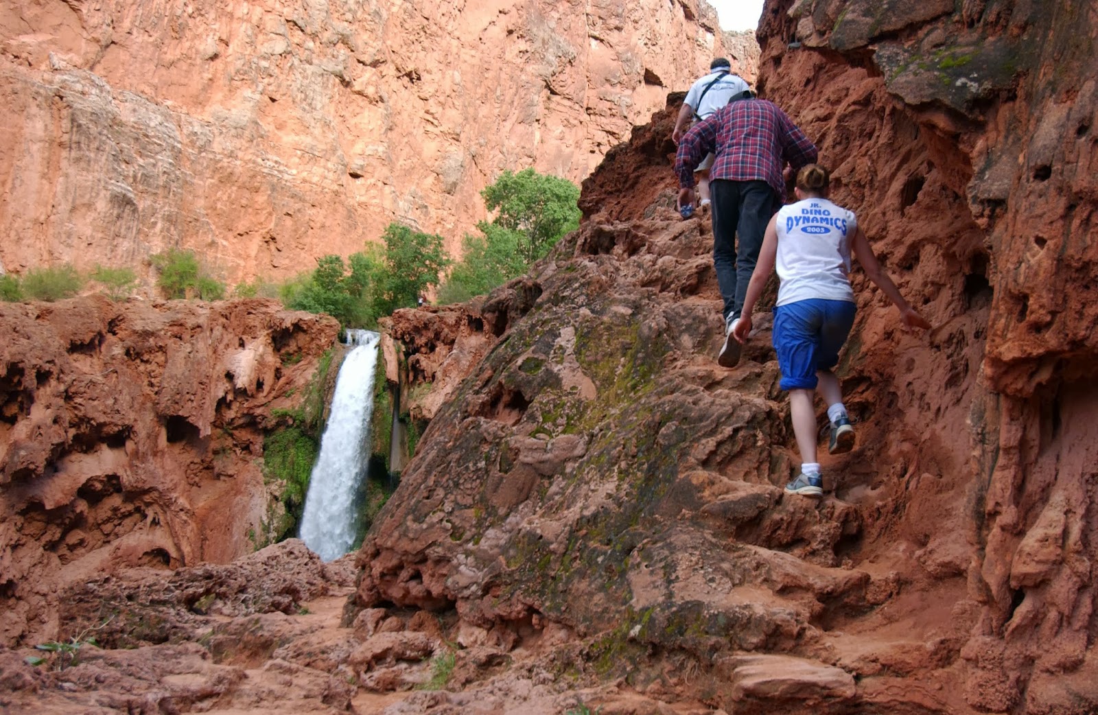
                               The scramble down to Mooney Falls.

For a mile beyond Havasu is Mooney Falls, where, as Iliff wrote, the river roars "in a solid column over a ledge higher than Niagara." Today that mighty ribbon of water, which drops 196 feet, is named for an early miner who fell to his death there. However, to the Havasupai of Iliff's time it was the "Mother of the Waters."


Beyond the first viewpoint . . . and maybe even there . . . Mooney isn't really a place for acrophobics.
"Descend at own risk," warns a trailside sign. "Exercise extreme caution."

"Go slow," Billy Jack advised.
Two tunnels, chains and ladders help hikers approach the mighty cascade and its large pool. Jagged, red-tinted travertine shields, similar to stalactites, decorate the chasm's walls and, with the tunnel openings frame the exquisite waterfall.


Hikers with more sightseeing time can venture even farther down Havasu Canyon to Beaver Falls (four miles distant) and the Colorado River (another three miles). Our plan of action, however, called for a return by nightfall to the Supai lodge.
The next morning we were to retrace our steps, trudging 

stoically back to Hualapai Hilltop — knowing full well that it 

would be much more pleasant to be spending a bit more 

time soaking in the delights of Navajo, Havasu and Mooney 

falls and Havasu Canyon.

------------------------------------------

--Some of the Supai residents have cars parked at the 

"Hilltop."

In recent years, there's now a night watchman at the parking 

lot to help curtail crime.

--Note that advance reservations are a necessity here, 

especially in the spring and summer seasons. Permits must 

be purchased just to travel the Supai area.


--Also, since our trek drew attention in the LDS Church-

owned Deseret News, church sent members from 

Kingman, Arizona and reopened a church branch there after 

some 20 years of absence.

(-Revised and originally published in the Deseret News by 

Lynn Arave and Ray Boren on May 9, 2004. All 

photographs  by Ravell Call.)


                        Most of our group lines up before leaving Supai.


                                          Walking out of town.